

What is Precision Agriculture? What are its main objectives? What kind of benefits are provided? How can it be done? In this article you will find the answers to these questions and many more. Have a nice read!
In the field it is very common that the production is not homogeneous, that is there are zones where the production is higher and less productive ones. This inconsistence in the production may depend on various causes, even by an incorrect application of the fertilizer or a bad seeding process.
Anyway, often this variability is caused by some kind of natural elements: for example, a different composition of the soil; the presence of slopes, where water is stagnant, or more compacted zones with less porosity.
Be capable of understanding what generates this variability and then finding out the ways to solve it, when possible, or to adapt the production in order to reduce the wastes are the tasks of the Precision Agriculture (PA), also called Precision Farming (PF).
The variability is not present in the space only (here is different from there) but also in time (Today is different form Yesterday). To manage the variability means that the productive process, once gathered the information, is applied in a diversified manner. For example, where production has been lower, we could increase the fertilization for a better growth of the crops, or vice versa, reduce it in zones where the soil has inner characteristics which cannot be changed (ex. soil texture).
To do this, is necessary having proper techniques and technologies, to identify inhomogeneity first, and after, to apply cultural solutions to the field. Obviously, the utilization of agricultural facilities (soil preparation, fertilization, treatments, seeding, etc.) will be always done according to the type of crop, chemical-physical properties of the soil, climate and weather.
The PA can use different strategies and technologies which may operate in a georeferenced manner. The location referencing is a technique, well known by most of the people, which allows to keep informed about the exact position of the machine (the precision degree depends on the referencing system) during the work thanks to the connection between a receiver and satellite-devices.
It is useful to precise that the Precision Agriculture can be used also in higher difficulty steps: driving assistance, variability management, tracking, expert system development; all these steps may contribute to a better agricultural production efficiency and a reduction of environmental impact.
Variable rate
To manage the variability of the crop environment, means to apply the inputs (chemical, mechanical and biological) in a diversified and consequent manner.
The methods to face the variable distribution (or variable rate) are mainly two: the one set on maps and the other one which uses the sensors. Both systems comply to the Precision Agriculture philosophy, even though they are very different from each other.
The variable rate based on sensors, uses devices which can determine in real time all the relevant data (chemical-physical characteristics of the soil, crop vigor, absence/presence of weeds/plants, etc.) to be utilized 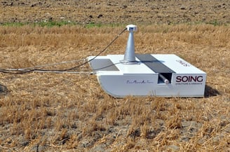 as indicators to manage the operations. This method doesn’t require a satellite-receiver.
On the other hand, the variable rate based on maps adapts the distribution quantity to the field characteristics present in the system’s prescription maps. This method requires a machine localization system in the field which can communicate the amount of product to be distributed in that point.
In the side picture we could observe an instrument capable of a magnetic scan of the soil, useful to identify homogeneous areas (for soil characteristics). This information combined with soil texture is often required to build prescription maps.
This system allows to previously decide the work intensity or the quantity of product to distribute and, in the range of time between the maps analysis and application, improve the treatment accuracy in some cases. In other circumstances it could be a constraint, for example for applications where the characteristics keep changing (nitrate content, soil humidity, etc.) Therefore, the application maps are sometimes formed by a limited number of points, meanwhile the sensor can (or could) gather all the space variability
However, today a few field sizes can be explored by the sensor with reliability. Therefore, in the distribution based on sensors, is not present a direct human action, so it’s possible to discover the distribution effect only after it. On the other hand, this application method requires less investments of both money and time, because complex systems are not necessary as for build up the prescription maps.

Precision agriculture without location referencing
Let’s examine some Precision Agriculture technologies which cannot operate without georeferentiation, in other words, which operates as the principles above but without the use of satellite-receivers. Sometimes are used by the farmer in an unconscious manner, so he’s unaware of using the Precision Farming. Some examples could clarify how these technologies work and where they are used.
In the beds preparation for horticultural purposes it is very important that the soil doesn’t present slopes where the water can stagnate, or in the case of baby leaves and more in general Ready – to- Eat Products, allows an 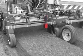 easier harvesting process. To obtain this result is not sufficient a well-organized field; it is necessary by the way that the machine has to be set to work constantly and homogeneously. The application of a sensor capable of read the distance from the ground and a series of actuators which can adjust the position of the bed former in relation to the soil, permit to obtain perfectly horizontal beds. In this picture we can see an example of electric device used for measuring the distance from the ground, which allows to adjust the bed former set-up, obtaining a perfect flat and horizontal seeding bed.
 The NDVI sensors (Normalized Difference Vegetation Index), allow to evaluate in real time the photosynthesis capacity, so the crop vigor. The use of these sensors in the cover-up nitrogen fertilizing phase, permits to modify the distributed amount according to the crop vigor degree. Obviously, the machine which operates the treatment (liquid in general, but not necessary) must be equipped with devices that allow to modify in real-time the distributed dosage. This is the typical distribution with variable rate executed on the measurement on the field, by the sensor, and not on prescription maps.
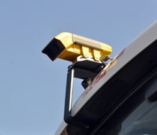
A third example is the application of optical system, regulated to recognize the weeds, mounted on the machines which can mechanically or with the distribution of herbicide, eliminate those weeds. The work intensity, the distributed dosage, the limited distribution only where needed, are examples of a variable application of the production factors, done by the measurements and data collection in the field, here processed in real-time. If these information are memorized and georeferenced, they could also be processed into maps, compared to other measurements in order to get information to plan the most effective agronomic strategies for the next crops. So, georeferentiation offers larger application possibilities.
Precision georefenced agriculture
The application of sensors on harvesters capable of geolocalized recording, quantity, humidity and many others quality parameters of the product, allows to measure the product variation and to determine the quality and sanitary aspects of the products.
 A next process, nowadays automatically done by normal devices, permits to visualize on map the obtained results, just because that particular information has been collected through location referecing. This type of systems’ capacity is, in fact, to manage all the data within the referential coordinates, so those can be attributed anytime to the occupied place in the field.
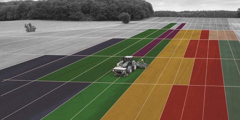
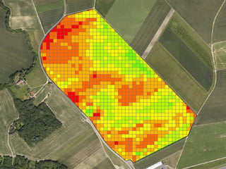
The production map is a fundamental instrument for the Precision Agriculture; thanks to it, it is possible to understand in which measure the variability manifests itself. The production map though, doesn’t inform about the causes of the variability, which is the essential information in order to find out a remedy.
It necessary to collect all the information, always structured in maps, which could explain why some field sectors were more productive than others. There are in fact programs which allow to overlap different information but related to the same area; in this way it’s easier to understand their relations in the examined area.
With all these information (represented in maps), on the basis of our agronomic knowledge, we can assume a basic strategy related to intensity and quantity, applied to different operations. Decided this passage, a map (which can be virtual as well) will be realized which will manage the machine during the operation.
The maps may be represented in various forms and formed on the basis of different information, which analysis allows to create a prescription map, with the proper elements.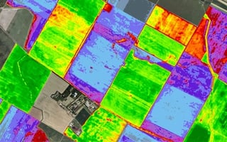
The implementation of the production maps, integrated with other information (for example those regarding the soil composition, types of jobs done, soil vigor, etc.) guides to a complete and full application of the Precision Agriculture. In fact, after a few years will be possible to dispose of a georeferenced representation of the production variability and the effects of the adopted strategies.
Conclusion
Precision Agriculture, as explained, has as target, to increase the crops’ productivity reducing the performance differences in the production area, and can it can be implemented through different ways. It’ s a very particular topic, which interests the entire agricultural sector, in order to find out even more precise and reliable methods to recognize the variability.
We hope this article has been helpful and informative regarding this topic. If you have other questions or you would like to know how the Forigo team is involved in this solution, don’t hesitate to contact us! We will be glad to answer your questions.